
Watershed Monitoring: Leveraging Geospatial AI for Verifiable Resilience
The health of a watershed—the area of land that drains into a specific river, lake, or bay—is a foundational indicator of environmental stability and supply chain resilience. For businesses driving Regenerative Agriculture and robust ESG reporting, monitoring the health of surrounding watersheds is critical for managing water risk, verifying biodiversity efforts, and ensuring sustainable sourcing.
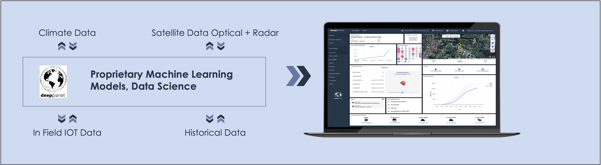
Deep Planet leverages GeoSpatial AI Insights and remote sensing data fusion to provide precise, scalable monitoring solutions for watersheds.
Why Watershed Monitoring Matters
Safeguarding Water Resources - Watersheds determine where water comes from, where it flows, and who relies on it. When land use shifts — from deforestation to urban expansion — water quality and availability can change rapidly. Monitoring helps decision-makers anticipate shortages, manage reservoirs, and protect drinking water sources and make more informed responses.
Protecting Investments - Flooding, erosion, land degradation and declining vegetation can all impact supply chains, farms, and assets. Watershed monitoring helps identify risk areas early, allowing proactive management and guiding long-term planning.
Supporting Sustainable Growth and Regulatory Reporting - Watershed-level insights support internal reporting, water-use disclosures, biodiversity metrics and compliance with environmental standards.
Deep Planet’s GeoSpatial AI Methodology
Our approach to watershed monitoring integrates diverse data sources to provide a comprehensive, real-time view of environmental health across the entire drainage basin:

Figure 1. Landcover map of a single watershed in the UK in 2021. It shows the different land classifications (colours). It is integrated with our water body detection, and water and soil quality monitoring to deliver insights on regions which are at high risk
1. Defining the boundaries with Digital Elevation Modeling (DEM)
Boundary Detection: We use Digital Elevation Models (DEM) to precisely map the topography and define the watershed's outer edge. This work is typically performed using Geographic Information System (GIS) software like QGIS.
Integrated Visualisation: The derived boundaries and geospatial data are then layered into user-friendly portals or existing GIS systems, enabling a unified operational view for our clients.
2. Monitoring Vegetation and Land Cover Degradation
The quality and type of vegetation covering a watershed directly impact water runoff, filtration, and soil retention.
Landcover Mapping: Our habitat classification model monitors and segments habitat types, creating vegetation maps and time-series landcover maps using high-resolution satellite imagery.
Key Parameters: This allows for the estimation of critical parameters, including vegetation health, land use, and the monitoring of degradation of vegetation cover over time.
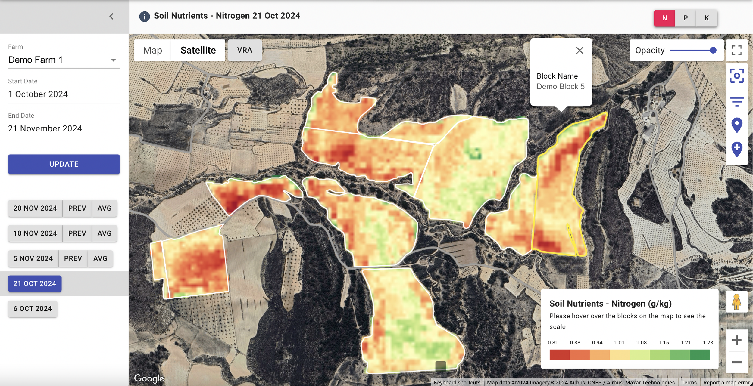
Deep Planet’s nutrient maps for large scale regional agricultural monitoring with weekly or monthly frequency.
3. Water Quality and Soil Health Monitoring
Understanding the state of the water bodies within the watershed is crucial for both environmental compliance and risk management.
Water Body Analysis: Our AI models to detect water quality parameters remotely, we are able to monitor water bodies to provide a remote quantitative assesment of the water quality. Read more about our project with European Space Agency, Krucial and CEOS here.
Soil Health Integration: Water quality assessment is often coupled with monitoring of surrounding fields, where we track remotely soil carbon, nutrients (N, P, K), to assess upstream impacts on water quality particularly with over application of fertilisers or chemicals. Read more about our AI models for soil nutrient monitoring here.
Benefits
By integrating these GeoSpatial AI models, organisations can strengthen business resilience while demonstrate environmental stewardship. It enables
Risk Reduction and Resilience - Providing data for strategic planning and supply chain risk analysis related to water scarcity and land degradation.
Operational Efficiency - Reducing the need for costly manual monitoring and field work, improving data consistency and efficiency.
Sustainability targets - Delivers verifiable metrics for internal reporting, regulatory compliance and robust internal reporting on sustainability targets.
Watershed monitoring is a strategic tool for organisations navigating regulatory pressures and sustainable growth targets. Deep Planet is committed to pioneer AI techniques to turn complex environmental data into clear, actionable intelligence for a resilient and sustainable future.