
Find and Monitor Tree Crops for Sustainability
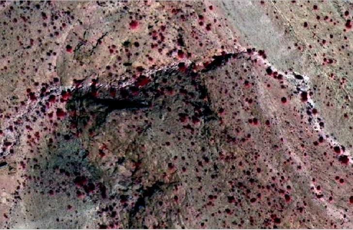
Wild Crop / Tree Detection with High Resolution Satellite Imagery / Image: WV-2 ©2020 Digital Globe
We can monitor agricultural production around the globe using satellites. Recently, there has been an increase in the number of satellites and the frequency and resolution of images being captured. Such large amount of data on a daily and weekly basis can be used with AI to detect crops.
Current Best Practices
Supply chain companies use manual scouting and surveys up to three times a season to identify what crops are grown where and estimate what yields will be produced. This has led to inaccuracies in crop mapping and sub-optimal supply planning. Recently, drones and airplanes are used to map crops. However, they are expensive to procure and maintain and cannot scale over large areas.
Why do Supply Chain Companies need it?
Knowing where the trees are growing, what species they are, how many are there and what yield they will achieve is important information that supply chain companies can use to make decisions. This helps in planning activities and making optimal sourcing decisions. It also supports proactive mitigation of supply issues and ensures sustainable supply, while gaining over competition.
In regions that are not suitable for manual scouting, monitoring tree and forest health is difficult. Using satellite imagery would be a cost effective way to achieve this.
Further, regulatory pressures and national interests are putting the supply at risk. Better understanding of which regions and countries the trees are grown in along with their estimated yield can help in risk management planning.
Satellite Imagery + AI can help

Tree Health Monitoring with Normalised Difference Vegetation Index (NDVI) / Image: WV-2 ©2020 Digital Globe
Detect and count trees:
Using a combination of high resolution and low resolution satellite imagery and ground data, our product PlantSignal can detect wild trees with a confidence level of 90%.
Yield prediction:
Ground data, satellite data, health data among other data sets are used to provide a yield forecasting.
Regular monitoring:
We use historical satellite imagery to monitor the health of the trees and provide key information on the changing health conditions. With climate change and human encroachment into forests, this it become important for supply chain companies to not only know where their supply is coming from but also to become aware of its health condition trends. This allows for better yield estimation and thus supply planning.
People and Planet:
Many agricultural supply chain companies are investing in sustainability and also focusing on the planet and people side of the triple bottom line framework. Helping local communities thrive while ensuring sustainable harvesting has become important. Satellite imagery can assist in tracking if trees are over harvested or dieing and which regions are to be avoided.
As Food and Agriculture Organisation (FAO) policy brief states that the pandemic has put a strain on the agricultural supply chain and could lead to disruption in supply chains in the coming months. Identifying and locating supply has become more critical now than ever.
Satellite imagery can be used to detect trees, monitor their health and predict yield. This can provide new insights and perspectives into the supply chain decision making process to help you secure your assets, identify risks and ensure sustainability.
Would you like to know more about how satellite imagery can help you improve your supply?